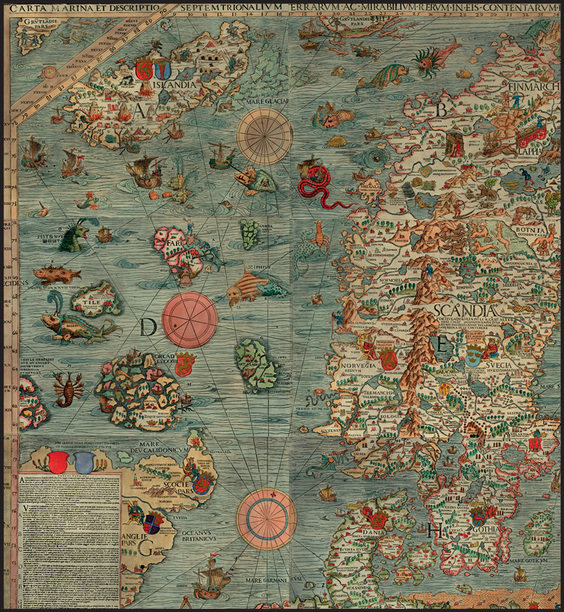
By now, if you follow this blog, you must have noticed that I've got a thing for maps and monsters. When the two come together, you can imagine how excited I get! Yesterday I wrote about a couple of monsters that appear in Olaus Magnus' Carta Marina, and, today, I'll discuss it a little bit further.
For startes, the complete name of the map is Carta marina et descriptio septemtrionalium terrarum ac mirabilium rerum in eis contentarum diligentissime eleborata anno dni 1539, which can be translated as "A marine map and description of the northern countries and their remarkable features, meticulously made in the year 1539." It represents the beggining of Swedish cartography, and the representations of the Nordic countries were quite accurate!
Magnus was a Swede church man and he worked in the map for 12 years (!) before it was finally printed in Venice in 1539 with the title Carta Marina. You can see in the picture above that there are commentaries in the bottom left-hand corner. Those are in Latin, but there were also Italian and German commentaries printed separately.
The map itself consists in 9 separate sheets of black and white paper (the color is a modern addendum, I believe), each one measuring 55 x 40 cm and printed separately. Arranged in 3 x 3, the sheets form the map, which is 125 cm high and 170 cm wide.
The Carta Marina can be considered the predecessor of Magnus' great work: Historia de gentibus septentrionalibus (A History of the Nordic people), printed in Rome in 1555. That was the first description of the Nordic peoples and their countries. It is directly connected with Carta Marina, and some historians regard it as a comprehensive commentary to the map.
~Ally

 RSS Feed